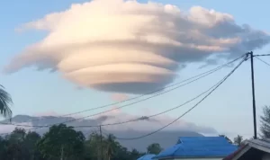
JABAR EKSPRES – The Regional Disaster Management Agency (BPBD) confirmed the appearance of rare cloud in the sky of Ranai, Natuna Regency, Riau Islands Province, on Sunday (5/7) afternoon until night.
“The rare cloud phenomenon occurred at around 3pm, until the evening. But, this morning it is no longer there,” said Zulheppy, head of the Natuna BPBD‘s emergency and logistics division, on Monday (5/8).
He said the vortex-shaped cloud could be clearly observed from residential areas in Ranai, so many of them captured the rare moment with cell phones and then broadcast it to various social media platforms.
Baca Juga:Mayor Offers Northern Medan to ASEAN InvestorsPresident Director of Jamkrindo Has Passed Away
“Photos and videos of this cloud went viral on social media. Moreover, it was the first time it happened in Natuna,” said Zulheppy.
Meanwhile, Forcester BMKG Ranai, Reza Pahlevi, said that the phenomenon that occurred in the sky was quite rare.
“These clouds are Lenticularis clouds or commonly called hat clouds,” he said.
According to him, these clouds are usually formed by mountain waves triggered by a strong wind blowing from one side of the mountain.
Then the horizontal wind passes through the mountain wall, causing a deflection that forms a mountain wave on the other side of the mountain.
“Lenticularis clouds indicate vertical turbulence or strong winds. So it is dangerous for low flights around the clouds,” he said.
He said Lenticularis clouds begin to form when wind currents flowing parallel to the earth’s surface encounter obstacles from certain objects, such as mountains. As a result of these obstacles, the air current rises perpendicular to the top of the cloud.
Baca Juga:Bogor Traffic Police: Weekend Traffic Congestion Drops 12.92 PercentBPBD Urges Residents to be Aware of Soil Liquefaction Disaster
He explained that when the air rises, it contains a lot of water vapor and is stable. When the dew point temperature is reached at the top of the mountain, water vapor begins to condense into clouds that follow the contours of the mountain peak. As the air flows down from the mountain peak, the condensation process stops.
